
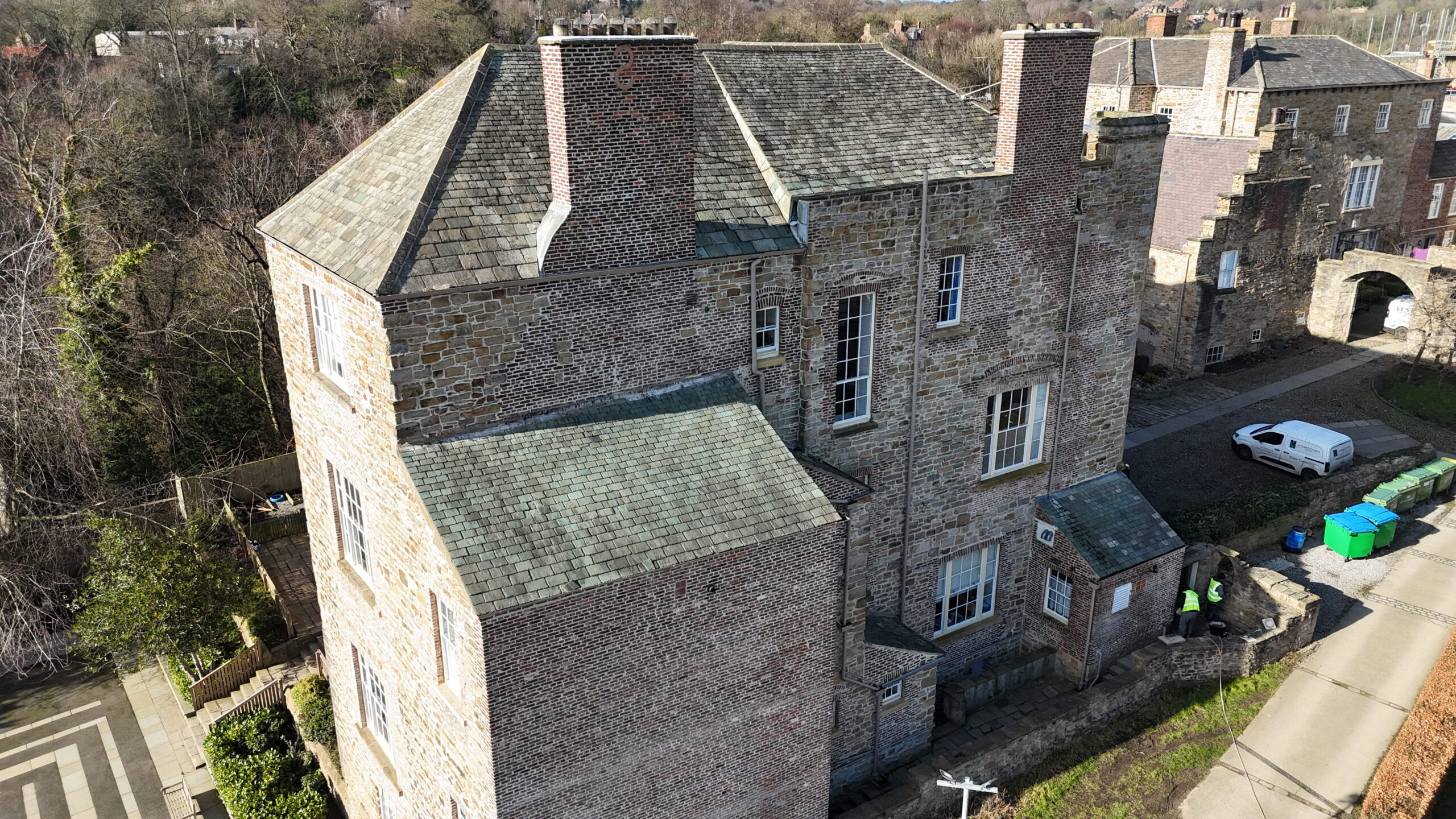
It is not always easy to see what is happening on a roof.
From the ground, most of us can spot an obviously missing tile or something that looks out of place. But that does not tell you much about the condition of the rest of the roof, chimney, masonry or other areas higher up the building.
This becomes even more difficult with larger properties, older buildings and buildings with features that are difficult to reach safely.
A drone roof survey provides a practical way of getting a much closer look. High-resolution photographs and video can show areas that would otherwise be difficult to inspect without access equipment.
So, what can a drone roof survey actually pick up?
1. Missing or damaged roof tiles
Roof tiles can become cracked, loose or displaced over time. Strong winds can also move tiles or slates, leaving parts of the roof exposed.
A missing tile may be obvious on the front of a house, but it is much harder to spot when it is on a rear roof slope or a higher section of a larger building.
Aerial images give a much clearer view of the roof covering and can help identify areas where tiles or slates appear damaged or out of position.
2. Problems with roof slates
Older properties often have slate roofs, and individual slates can deteriorate without the whole roof looking obviously damaged.
A slate may be cracked, slipped or missing altogether. Small defects can also become more troublesome when rain and frost get into the roof structure.
A drone survey allows the roof to be viewed from different angles, making it easier to identify areas that may need closer inspection or repair.
3. Chimney damage
Chimneys are one of the harder parts of a building to inspect from ground level.
You may be able to see the chimney itself, but getting a proper view of the upper sections, mortar joints and surrounding masonry is another matter.
A drone can provide detailed images of these areas and may reveal cracked masonry, damaged pointing, loose sections or other visible signs of deterioration.
This can be particularly useful on older and heritage properties where chimneys and other masonry features form an important part of the building.
4. Deteriorating pointing
Pointing does not last forever.
Exposure to rain, wind, frost and temperature changes can gradually affect the mortar between bricks or stones. On a large or tall building, it is not always possible to see how much of the pointing has deteriorated from the ground.
Aerial photographs can help show whether the issue appears to be limited to one area or whether there are larger sections that need attention.
For older masonry buildings, this type of information can be useful when planning future repair or conservation work.
5. Cracks in masonry
Cracks in brick or stonework should not simply be ignored, particularly when they are high up or difficult to examine closely.
A drone survey can provide clear images of areas that may otherwise go unnoticed. This might include upper sections of walls, around chimneys, gable ends or other difficult-to-reach masonry.
A drone survey will not determine the cause of a structural crack. That requires appropriate professional assessment. What it can do is help identify visible areas of concern and show where further investigation may be worthwhile.
6. Damage to stonework and architectural features
Historic and heritage buildings often have stone features that are difficult to inspect properly from the ground.
This could include stonework around roof lines, chimneys, parapets or other high-level architectural details.
With detailed aerial imagery, these areas can be recorded without immediately needing to arrange extensive access equipment.
For buildings where original stonework and architectural details need to be preserved, having a clear visual record can also be useful when considering future restoration or repair work.
7. Blocked or damaged gutters
Gutters are easy to forget until they stop doing their job.
Leaves, moss and other debris can build up over time. Gutters can also become damaged, poorly aligned or develop problems around joints and outlets.
On a tall building, checking the guttering properly from the ground can be difficult.
A drone survey can provide a much better view along roof edges and around gutters and downpipes, helping to identify visible problems before they contribute to water damage.
8. Signs that water may be getting in
Water ingress can be frustrating because the place where you notice damp inside a building is not necessarily where the water is entering.
The source could be a damaged roof covering, defective pointing, a problem around a chimney or another external defect.
A drone survey cannot diagnose the source of every leak, but it can help identify visible external areas that may warrant closer investigation.
That can save time when deciding where to look next.
9. Storm or weather-related damage
After strong winds or heavy weather, it can be useful to check the condition of a roof and the upper parts of a building.
Tiles and slates can move. Masonry can be affected. Chimneys and other exposed features may also need checking.
Rather than immediately arranging access to every part of the building, a drone survey can provide an initial visual assessment.
This is useful for residential and commercial properties, but can be particularly valuable for older buildings where access to roofs and high-level masonry may be more complicated.
10. Areas that are difficult to inspect from the ground
Sometimes the main problem is simply getting a good view.
A large commercial property may have extensive roof areas. A residential property may have a steep or awkward roof. A historic building may have high-level masonry or architectural features that cannot be properly seen from the pavement.
In these situations, aerial imagery can provide information that would otherwise be difficult to obtain.
It can also help establish whether further access is actually needed and, if so, which areas require closer attention.
Why are drone surveys useful for heritage buildings?
Historic and heritage properties often need a slightly different approach.
The roof is only one part of the building. Chimneys, stonework, brickwork, pointing and architectural details can all be important, and some of these areas may be difficult to inspect safely from the ground.
A drone survey can provide detailed images of these features without disturbing the building.
For a property owner, this can be useful when assessing the current condition of a building, planning repair work or deciding whether a more detailed inspection is required.
For masonry and conservation work, having clear photographs of the existing condition can also help provide a better understanding of where attention may be needed.
When is a drone roof survey worth considering?
You do not necessarily need to have a known problem before arranging a survey.
It may be useful if you are concerned about the condition of a roof, have noticed signs of water ingress, are dealing with storm damage or are planning repair work.
It can also be worthwhile when buying or managing a property and you want a clearer view of areas that are difficult to inspect from the ground.
For commercial and heritage properties, the size, height or age of the building can make a visual survey particularly useful.
The important point is that a drone survey gives you information before you decide what needs to happen next.
A drone survey is not a replacement for every inspection
It is important to understand what a drone survey can and cannot do.
It provides a visual assessment using detailed photographs and video. It can highlight areas that appear damaged or require further investigation, but it cannot reveal every hidden defect or determine the underlying cause of a structural problem.
If a survey identifies something concerning, a closer inspection may still be necessary.
In many cases, however, having a clear picture of the building first can make that next step much more focused.
Get a clearer view of your roof and building
Whether it is a residential property, commercial building or historic property, some areas are simply difficult to inspect from the ground.
A drone roof and building survey can provide detailed imagery of roofs, chimneys, masonry, gutters and other hard-to-reach areas, helping property owners understand what may need further attention.
At Colin Stephenson Masonry, we provide professional drone roof and building surveys for residential, commercial and heritage properties across Newcastle, Gateshead, Durham and surrounding areas.
If you are concerned about a roof, chimney, masonry or another difficult-to-reach part of a building, a drone survey can provide a useful first look before deciding on the next step.
Frequently Asked Questions
Can a drone survey find roof damage?
Yes. A drone survey can capture detailed images of the roof and may show missing, cracked or displaced tiles and slates, along with other visible signs of damage.
Are drone surveys suitable for heritage buildings?
Yes. They can be particularly useful for historic and heritage properties where roofs, chimneys, stonework and other high-level features can be difficult to inspect from the ground.
Can a drone survey check chimneys and masonry?
Yes. Detailed aerial images can show chimneys, brickwork, stonework and pointing. If an area looks damaged or requires further investigation, a closer inspection can then be arranged.
Do I need scaffolding for a drone roof survey?
Not necessarily. A drone can provide access to views that would otherwise be difficult to obtain without scaffolding or other access equipment. If a physical inspection is required afterwards, suitable access may still be needed.
Can a drone survey identify the cause of a building problem?
Not always. A drone survey provides a visual assessment and can highlight areas of concern, but some problems require a closer physical inspection to establish the underlying cause.


